1. Welcome to Anafi island
Anafi is gradually growing as far as tourism is concerned. It is currently in a position to offer all necessary services to its guests, who do not arrive in Anafi as a regular tourist, but usually have all the characteristics of the explorers of old times; explorers of a virgin and unworldly landscape, discovered each time a new by land and by sea. There are day trips from Anafi to the beautiful island of Santorini. Anafi is a very small, peaceful and quiet island in the Cyclades, it has a population of 330 inhabitants. It has an area of 38.4 m2, a coastline of 32.4 kilometres and a maximum altitude of 579 meters (Mount Vigla). The island’s distance from Piraeus port is 155 nautical miles.
You will arrive at the port of Ai Nikolaos and then most people head for the capital which is called Chora, Chora is also the only village on Anafi. Tourists that visit Anafi will fall permanently in love with the unique landscape, the traditional Cycladic architecture and the wonderful hospitality offered by the friendly Greek people of the island.
Transactions: There are no banks on Anafi. Any necessary transactions can be carried out via an ATM machine.
Medical: On the island, a pharmacy does not exist. Medicines are given out by the small health centre with a health book (vivliario igeias).
If you would like to visit the beautiful island of Anafi, you may book your accommodation through our site and get a special discount. If you have fallen in love with Anafi and you wish to stay, then perhaps you should look at some of the real estate on Anafi options!
If you need any extra information, then please contact us here [email protected] or +30 6934 620 501 (Whatsapp also!) or viber: +30 6909463436
2. Activities on Anafi
The beach in the little harbour Ayios Nikolaos is a nice, sandy one. You can also go to various idyllic beaches with a small boat starting from there. Anafi is foremost an island to relax on, so a bit of snorkelling or going on walks are your basic options. You can also go on day trips to Santorini.
If you are looking for a wild nightlife, don’t go to Anafi. If you prefer quieter places, where you can sit and relax in good company, then you’re in the right place. You’ll find some nice cafes in Chora and during high season there is even a disco.
Basically, the only shops are in Chora, and the variety is limited.
Please also take a look at sightseeing on Anafi
Footpaths of historical and cultural interest on Anafi
Anafi is an ideal destination for explorer-travelers, who will meet the challenge of discovering unknown facets of the Anafian countryside, through an extensive network of selected footpaths. This network, with an overall length of 18 kilometers, covers most of the island and forms the Footpaths of Historical and Cultural Interest, which cross sites or lead to destinations that have a special historical-cultural or environmental significance.
The routes are as follows:
The Monastery is the most important destination and the end of the route. The footpath in the section from Chora to Roukounas is interrupted several times by the main road and other interventions but is generally well-preserved. The going is smooth, as the footpath crosses areas without any significant gradient. Chora – Roukounas – Ayios Ioannis – Megas Potamos – Zoodochos Pigi Monastery (Kalamiotissa).
The footpath starts outside Chora, at the crossroads of the road leading to the Monastery and the road leading to the port. A special sign points hikers in the right direction. The path is parallel to the coast most of the way, and crosses the island’s southern section, with direct access to the beaches of Mikros and Megalos Roukounas, Katalymatsa, Megas Potamos, Ayioi Anargyroi and Prassies. Several sections of the footpath are paved.
The route can also be taken backwards: Zoodochos Pigi Monastery – Megas Potamos – Ayios Ioannis – Roukounas – Chora.
Duration of route: 2 hours 15 mins – 2 hours 30 mins.
Kastelli – Iera Odos [Agios Mamas – Zoodochos Pigi Monastery].
The footpath begins at the point that is signposted towards Kastelli on the Chora – Monastery main road. The footpath crossing the archaeological site is very well-preserved and the route is particularly interesting.
Heading north, the footpath reaches the country chapel of Ayios Mamas, the site of an ancient temple where hikers can also see ruins of ancient tombs. The path continues on smoothly to Iera Odos – the ancient route linking the city to the famous temple of Apollo – with paved sections in places. The route then moves on to Mount Chalepas. There is an incredible view of the open sea from both sides of the footpath, near the isthmus where the monastery is located.
The route can also be taken backwards: Zoodochos Pigi Monastery – Ayios Mamas – Kastelli
Duration of route: 1 hour 30 mins.
Ayios Mamas – Ayios Dimitrios – Ayios Antonios.
Starting off at Ayios Mamas, the route heads northwest, along a dirt road that ends in the Ayios Dimitrios area, in a cluster of traditional homes. From that point, the well-preserved footpath heads downhill crossing an area with a view of the open sea, encountering a series of dwellings and ruins of ancient buildings.
Arrival at Kastraki, a precipitous location crowned by the tiny monastery of Ayios Antonios, is a unique experience for all hikers. The custodian of Ayios Antonios has to be notified in advance if visitors wish to enter the church itself, with its unusual architecture and 14th-century Byzantine frescoes.
Duration of route: 1 hour 15 mins.
Particular attention is required in the presence of strong winds. However, climbers will be compensated for their efforts by the view in all directions, both during the climb and at its end (old Kalamiotissa Monastery). Entry to the Panagia church is subject to prior arrangements.
Duration of route: 1 hour 15 mins – 1 hour 30 mins.Zoodochos Pigi Monastery – Kalamos (old Kalamiotissa Monastery).
The route presents mountaineering features. It starts at the Monastery, passing above the north-facing bay of Chalara. The uphill footpath is often quite steep and climbs precipitous and often dangerous parts, which, however, are protected by railings.
Chora – Stavros – Rachidi – Lakkous.
Starting from the centre of the village, the footpath heads north to the heart of inland Anafi. The footpath is uphill and well-preserved up to the Byzantine chapel of Stavros, the route’s main stop.
For the next 500 meters, the route follows a rural road leading to Rachidi, passing Vigla mountain to the west. The landscape is characterized by a multitude of farmhouses. The route then continues along a downhill footpath, leading to the rural area of Lakkous, which used to be full of life.
The route can also be taken backwards: Lakkous – Rachidi – Stavros – Chora.
Duration of route: 1 hour 30 mins – 1 hour 45 mins.
3. Best beaches on Anafi
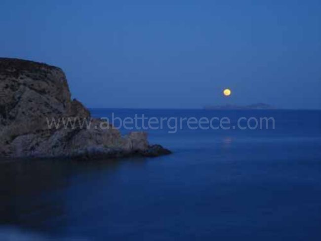
The beaches of Anafi island in Greece are famous for their golden sand and the crystalline waters as well as for their tourist and sports facilities and for the great fun they offer. Most beaches of the island can be found in the southern coast, which gets extremely crowded during the peak summer season.

best beaches on Anafi island
The next stops, Katsouni, Flamourou and Mikros Roukounas, are remote little coves with fine golden sand and transparent waters. Kleisidi beach: Starting at the port for a tour along the southern coastline, Kleisidi, a small oasis, offers a splendid sandy beach, accommodation in the form of rooms to let, and local delicacies from its picturesque fish taverns. It is just a twenty-minute walk away from the main port of Anafi ”Ayios Nikolaos” Kleisidi beach on Anafi is a nudist beach and so are the small beaches and coves in the area. There are many restaurants, hotels, and taverns at a very close distance to the beach.
Megalos Roukounas: Megalos Roukounas is the island’s most popular sandy beach and a major meeting point for summer nature-lovers. It is quite long (around 400 meters) and is the outlet of a gorge that forms a small plain with olive trees and prickly pears. There are a tavern and rooms to let in the area.
The next small beach is Katalymatsa, known from the remains of the ancient port, which can be seen scattered throughout the area.
Megas Potamos is a pebbly beach, formed by the eponymous gorge that forms a deep valley between Kastelli hill and the mountainous range of Chalepa.
Further on, Ayioi Anargyroi is a small beach surrounded by steep cliffs and framed by the eponymous country chapel.
The circular tour of the island’s smooth coastline ends at the small bay of Prassies, the former seaport of the Monastery and disembarkation point for pilgrims; the bay is enclosed by the majestic volume of Kalamos.
Continuing the coastal tour to the northwest, visitors will encounter the lonely presence of the tiny Byzantine monastery of Ayios Antonios, above a cliff and very close to the sea. This is followed by the coves of Ayios Georgios with the eponymous chapel, and Symiakos, at the island’s northernmost edge.The circumnavigation of the Kalamos peninsula, is a unique experience for travelers, as the limestone cliffs rise imposingly above the boat, to an altitude of more than 350-400 meters. This site is a special challenge for mountaineers and climbers, as it is a unique venue for both mountain and sea sports.
Prasa beach, Vagia beach and Kyparissi beach: The end of the tour to the west and south brings travelers to the pebbly remote beaches of Kalaggathi (no road access), Prassa, Vagia, and Kyparissi. You can reach these beaches by a small dirt track by foot, not by car or motorbike. There is a small boat that does one days tours on Anafi and then the boat will take you to these beaches.
4. Sightseeing on Anafi
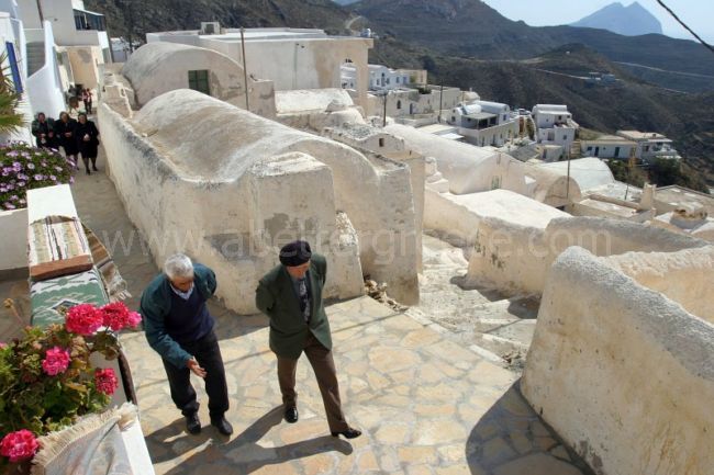
Chora: The village is densely populated and originates from medieval times. It is built theatrically above the port, at an altitude of 260 meters.
Pedestrians and animals are free to wander around, as Chora, being a traditional settlement, is off-limits to vehicles. Various taverns, a rotisserie, a bakery, a grocery store and a bar are available to the local population and visitors. Accommodation is provided by several rooms to let.With 270 inhabitants today, Chora is distinguished from the capital of other Cycladic islands due to its numerous arched single-room homes, which occupy a large area of the settlement. Narrow cobbled streets crisscross the village, leading to the Venetian Kastro (fortress), the initial nucleus and heart of the village. Several churches are scattered throughout Chora, including those of Ayios Nikolaos, the Kimissi (Assumption), Ayios Charalambos, Christos tou Stavrou (Christ of the Cross), Ayioi Anargyroi and Ayios Georgios at the top of the Kastro, all with Byzantine or post-Byzantine icons. Findings from ancient Anafi can be viewed in the Archaeological Collection.
Kastelli: Rich findings from the Roman period, during which the island flourished, are scattered throughout the area….
The hill on which the ancient city was located extends to an altitude of 327 meters. Ruins of the Asti, the Anafian city-state can be seen there; the city was probably established in the 8th century BC by Dorian colonists and dominated island life until the end of antiquity.
The city walls, as well as extensive ruins of the city’s cemetery, can be seen at Kastelli. Rich findings from the Roman period, during which the island flourished, are scattered throughout the area; one particularly impressive finding is the sarcophagus located next to the historic chapel of Panagia sto Dokari.
The Monastery of Zoodochos Pigi or Panayia Kalamiotissa is located over the narrow isthmus separating the main island from the Kalamos peninsula.Zoodochou Pigi monastery: The Monastery has functioned as a pilgrimage and is well-known both within and outside Anafi …
It is built over the eminent ancient temple of Apollo Aeglitis, which was linked to the Asti by the paved Iera Odos (sections of which can still be seen today). Quite high sections of the walls of the temple itself and its enclosure have been preserved and incorporated into the enclosure of the modern-day Monastery.
The Monastery has functioned as a pilgrimage since the times of Turkish rule and is well-known both within and outside Anafi. The island’s most important religious feast takes place there on September 7th-8th.
Kalamos:
of awe in all visitors…
The tall monolithic rock, inaccessible by sea and hard to reach by land, forms a unique natural monument for the island. It plays host to rare species of flora and has impressive geomorphological features. The rock was inhabited, on an occasional basis, at least, in Medieval times, as a refuge from the island’s numerous invaders.
Its highest peak hosts the now-abandoned old Kalamiotissa Monastery. It is a single-room domed temple with interesting architectural features, surrounded by a few monastic cells and a small water reservoir. Its location and the view inspire an indescribable sense of awe in all visitors.
Beaches on Anafi: Starting at the port for a tour along the southern coastline…
Anafi’s beaches constitute a comparative advantage for the island, in view of its unsullied, exotic character, which attracts visitors who enjoy remote landscapes. At the same time, the rocky coastline is particularly interesting to many categories of visitors.
Starting at the port for a tour along the southern coastline, Kleisidi, a small oasis, offers a splendid sandy beach, accommodation in the form of rooms to let, and local delicacies from its picturesque fish taverns. The next stops, Katsouni, Flamourou and Mikros Roukounas, are remote little coves with fine golden sand and transparent waters.
Megalos Roukounas is the island’s most popular sandy beach and a major meeting point for summer nature-lover. It is quite long (around 400 meters) and is the outlet of a gorge that forms a small plain with olive trees and prickly pears. There are a tavern and rooms to let in the area.
The next small beach is Katalymatsa, known from the remains of the ancient port, which can be seen scattered throughout the area.
Megas Potamos is a pebbly beach, formed by the eponymous gorge that forms a deep valley between Kastelli hill and the mountainous range of Chalepa.
The circular tour of the island’s smooth coastline ends at the small bay of Prassies, the former seaport of the Monastery and disembarkation point for pilgrims; the bay is enclosed by the majestic volume of Kalamos. Further on, Ayioi Anargyroi is a small beach surrounded by steep cliffs and framed by the eponymous country chapel.
The circumnavigation of the Kalamos peninsula, is a unique experience for travelers, as the limestone cliffs rise imposingly above the boat, to an altitude of more than 350-400 meters. This site is a special challenge for mountaineers and climbers, as it is a unique venue for both mountain and sea sports.
Continuing the coastal tour to the northwest, visitors will encounter the lonely presence of the tiny Byzantine monastery of Agios Antonios, above a cliff and very close to the sea. This is followed by the coves of Agios Georgios with the eponymous chapel, and Symiakos, at the island’s northernmost edge.
The end of the tour to the west and south brings travelers to the pebbly remote beaches of Kalaggathi (no road access), Prassa, Vagia, and Kyparissi.
The countryside of Anafi: Numerous characteristic country chapels decorate the hillsides…
The Anafian countryside is characterized by isolated clusters of farmhouses, the katoikies, which have common morphological elements that make them unique in the Aegean. They are located almost throughout the Anafian countryside.
Agricultural and livestock-breeding activities are still practised on the island, usually in areas near gorges and valleys, with scarce vegetation that makes them resemble oases in the bare and arid landscape of Anafi. Such areas include Vagia, Lakkoi, Vryssi, Drapano, Kammeni Laggada and Roukounas, where olive trees, vineyards, fig trees and prickly pears grow. Beekeeping is also particularly developed in the Anafian countryside.
Numerous characteristic country chapels decorate the hillsides; those of particular historical significance include the chapel of Stavros (15th century) at the foot of Vigla, Ayios Mamas and Panagia to Dokari near Kastelli, Ayios Ioannis Theologos in Drapano, Panayia ton Vouvon (Our Lady of the Mute!) towards Vryssi. Remains of an ancient observatory tower can be seen quite clearly at Pyrgi, above the southwestern edge of the island.
The “katikies” of Anafi
Each “katikia” is a complete agricultural facility, with ground-floor structures adapted harmoniously to the lie of the land. The “katikies”, many of which have been declared protected buildings, usually consist of eight separate structures: the house itself, the monospito or fournospito (baking-room), the oven, the stable and the pen, the barn, the threshing floor, and the xomantra (outside pen).The farmhouses of Anafi, the “katikies”, have always been the basis of the island’s agricultural economy. These were practically permanent residences of the farmers of Anafi in the past, and are occasionally inhabited today; they are scattered throughout the island.
5. Villages and settlements on Anafi
Anafi island is at a far remove from the rapid pace of modern development, at the edge of the Cyclades, sobered by the Aegean sun and sea salt, isolated in its simplicity.
Visitors will fall permanently in love with the unique landscape and the wonderful hospitality offered by the friendly islanders.
Anafi is gradually claiming its stake on the tourism market. It is currently in a position to offer all necessary services to travelers, who do not arrive in Anafi as a regular tourist, but usually have all the characteristics of the explorers of old times; explorers of a virgin and unworldly landscape, discovered each time anew by land and by sea.
Anafi is located at the southeastern edge of the Cyclades island complex; the nearest island is Santorini (Thira). It is administratively subject to the Cyclades Prefecture, and Thera province in particular. It has an area of 38.4 square kilometers, a coastline of 32.4 kilometers and a maximum altitude of 579 meters (Mount Vigla). The island’s distance from Piraeus port is 155 nautical miles.
Newcomers arrive at the port of Ai Nikolas and then head for Chora, the capital.
With an open view to the Cretan Sea, Chora is the only organized settlement, in the typical Cycladic style but with its own unique features. All excursions to the island’s “secret” and visible countryside start in Chora or the port:
The nearby picturesque beach of Kleisidi with its few scattered homes, and the exotic beaches of Katsouni, Mikros and Megalos Roukounas, Megas Potamos, Ayioi Anargyroi, Prassies….
Kastelli, a hill with ruins of an ancient city, and Katalymatsa, the site of the ancient Roman port…
The Monastery of Zoodochos Pigi (Life-giving Source) or Panagia tis Kalamiotissas, a famous Anafian pilgrimage and patron of the island…
The rough peninsula of Kalamos (altitude 459 meters), with the old Kalamiotissa Monastery at its peak…
6. The history and mythology of Anafi
Anafi (Greek: Ανάφη) is a Greek island community in the Cyclades. In 2001, it had a population of 273 inhabitants. Its land area is 40.370 km². It lies east of the island of Thíra (Santorini). Anafi is part of the Santorini peripheral unit.
According to mythology, the island was given the name Anafi because it emerged from the depths of the sea to give refuge to the Argonauts from a bad storm. Others say that the name is due to the non-existence of snakes on the island: ” An Ofis ” (without snakes).
In spite of its small geographical size, Anafi offers archaeological as well as mythological interest. At the monastery of Panayia Kalamiotisa, there are ruins of a temple built as an offering to the god Apollo Aegletus. Ruins can also be found at Kasteli, and most of the findings, such as the statues, are now located at the “Archaeological Museum” at the Chora, in an extremely small room housing these ancient findings.
Anafi is very much an island for walking. Through the old paths and around the steep hills, you could walk to the other side of the island. The most popular beaches would be Klisidi and Roukounas. A peninsula a the eastern end of the island is dominated by a monolithic peak, Mt. Kalamos, among the largest in the Mediterranean at 584 m (1,916 ft). Perched atop this massif is the Kalamiotissa church, rebuilt in large part after an earthquake in the 1950s. The journey to and from Anafi can only be done by boat, and since they have added more destinations on the way, it takes almost 19 hours.
Anafi and Santorini are the only places in Europe with hot desert climates according to the Köppen climate classification system.
ANAFI IN GREEK MYTHOLOGY
According to mythology, the island was given the name Anafi because it emerged from the depths of the sea to give refuge to the Argonauts from a bad storm. Others say that the name is due to the non-existence of snakes on the island: ” An Ofis ” (without snakes). In spite of its small geographical size, Anafi offers archaeological as well as mythological interest. At the monastery of Panayia Kalamiotisa, there are ruins of a temple built as an offering to the god Apollo Aegletus. Ruins can also be found at Kasteli, and most of the findings, such as the statues, are now located at the “Archaeological Museum” at the Chora, in an extremely small room housing these ancient findings.
7. Rent a car on Anafi
There are a couple of rental agencies on the island of Anafi! Here are the details:
The Rent a Car Moto Manos is located in Chora Anafi in the main parking lot of the village. Our experience is available to make your movements and rounds of the island as comfortable and as safe as possible. Website: www.rentacarmanos.com
Rent a car on Anafi with Margairita’s rent a car: Telephone: +30 22860 61292 or +30 6974 218741
8. Useful information about Anafi island

map of Anafi island
Anafi is a very small, peaceful and quiet island in the Cyclades; it has a population of 330 inhabitants. It has an area of 38.4 square kilometres, a coastline of 32.4 kilometres and a maximum altitude of 579 meters (Mount Vigla). The island’s distance from Piraeus port is 155 nautical miles. You will arrive at the port of Ai Nikolaos and then most people head for the capital which is called Chora, Chora is also the only village on Anafi. Tourists that visit Anafi will fall permanently in love with the unique landscape and the wonderful hospitality offered by the friendly people on the island. Anafi is gradually growing as far as tourism is concerned.
It is currently in a position to offer all necessary services to its guests, who do not arrive in Anafi as a regular tourist, but usually have all the characteristics of the explorers of old times; explorers of a virgin and unworldly landscape, discovered each time a new by land and by sea. There are day trips from Anafi to the beautiful island of Anafi. Transactions: There are no banks on Anafi. Any necessary transactions can be carried out via an ATM machine. Medical: On the island, a pharmacy does not exist. Medicines are given out by the small health center with a health book (vivliario igeias).
GETTING AROUND ANAFI There is a bus going between Ag Nikolaos and Chora, and a boat can take you to surrounding beaches. Because the island is so small and the roads are bad, you cannot rent a car. There are no taxis on Anafi
HOW TO GET TO ANAFI To and from Piraeus Anafi is connected to Piraeus by ferry 3 times a week. The ferries also call at: Paros, Naxos, Ios, Sikinos, Folegandros, Thera (Santorini), Kythnos, Serifos, Sifnos and Milos, depending on the itinerary. To, and from Thera (Santorini) and other Cycladic islands. Anafi is connected locally to Santorini on an almost daily basis. The duration of the trip is around 2 hours. The island is also connected to the following islands 2-4 times a week: Ios, Sikinos, Folegandros, Naxos, Paros, Mykonos, Syros, Kythnos and Kea. Santorini is regularly connected by air to Athens and several other European cities.
SOME USEFUL TRAVEL INFORMATION: Ferry schedules change often so I would advise you to book your ferry ticket around two weeks in advance, this way you can rely on the schedule not changing and not losing your ticket. If you are travelling in order to get on a connecting flight, then I will advise you to not leave it until the last minute, book your ticket around 2 weeks in advance and its is preferable to spend a night or hours in Athens rather to get on the last boat and then miss the bus to the airport and then miss your flight. Always double check the ferry schedules, as mentioned earlier, they change quite often.
Do not totally trust hydrofoils or catamarans, as if the wind reaches Force 6 on the Beaufort scale, they will not sail and if you are depending on the journey then you will come around a lot of problems that will be hard to find the appropriate solutions to. Most of the very old ships have been renovated or even excluded from the shipping companies but if you find an exception, then do not count on the ferry being on time or on having a comfortable journey.
Always check the weather schedule a couple of days prior to your journey. Ferries continue to sail until 9 Beaufort whereas hydrofoils and catamarans only sail until 5-6 Beaufort. Try to always get a second opinion from several different travel agencies about the information that you are looking for, as the staff in the travel agencies are pressured during the high season and mistakes happen. When you buy your ticket, please pay attention to the fine print on the back of the ticket or click here to see the rules and conditions of travelling by ferry. Children under the age of ten pay half the price of the ticket and children under four years of age travel free of charge but still need a ticket.
©2020 www.2paros.com | Permit number: EOT 0206E60000382501